


While I’m away this summer, I thought I’d share this piece that I wrote for the Friends of Brompton Cemetery Magazine. It was written with the cemetery in mind, but it’s also a nice case study of what London’s unbuilt urban motorways would have done to one very specific place and its neighbourhood.
Brompton Cemetery’s sacred status as a peaceful memorial to those laid to rest, and as a green oasis in urban West London, might seem beyond question. But it was not always so.
From the outset the Cemetery lay alongside a transport artery. Initially, its neighbour to the west was the Kensington Canal, but the waterway was soon replaced by a railway, and passing trains still provide a periodic reminder of the city that lies beyond its walls. But a different kind of transport entered the frame in the 1960s, when planners began redrawing the map of London with a network of urban motorways.
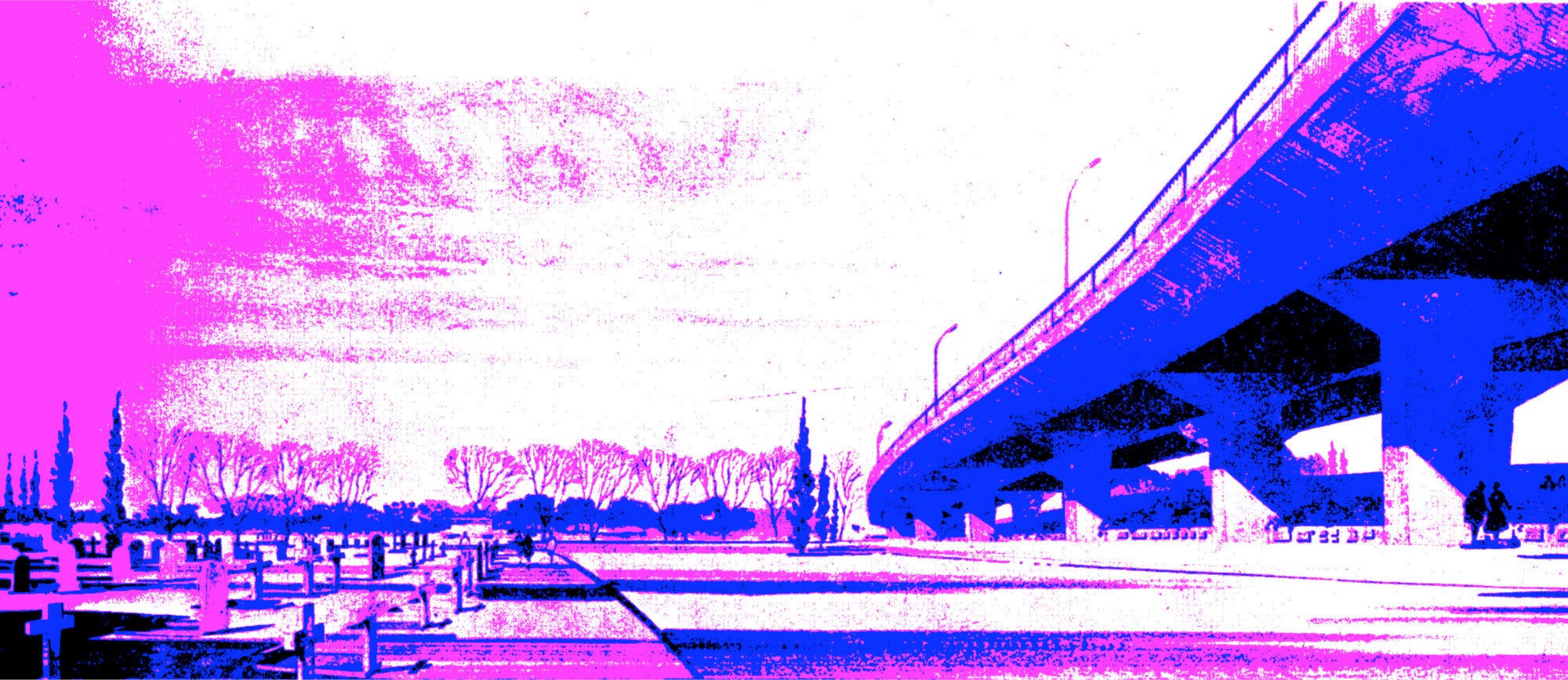
If they had succeeded, Brompton Cemetery would have been changed forever, cast into the shadow of an elevated motorway running the length of the western boundary, its tranquility forever replaced by thundering traffic noise.
But before we see the fate the Cemetery narrowly avoided, it’s worth asking what was happening to London as a whole.
In the 1950s, the streets were filling up, thanks to economic recovery and increasingly affordable private cars. In response, new sciences were developed in the study of traffic flow and the forecast of transport patterns. Academics applied these to London’s traffic congestion - by then a problem centuries old - and concluded that, without help, the city was heading for paralysis. So many vehicles would fill its streets that London would grind to a complete halt; business would become impossible and life would become unbearable. Something had to be done.
With some urgency the London County Council developed, in complete secrecy, a programme for an urban motorway network. When, in 1965, the new Greater London Council took over, efforts were redoubled and the scale of the network grew. The initial concept for a box-shaped motorway surrounding Central London became a network of four concentric rings pushing their way through the suburbs1.
Any plan of this kind is shocking today. The idea of demolishing some 36,000 homes to alleviate traffic jams sounds like madness, but its architects would have been surprised at the idea that they were destroying the city. Their belief was that they were saving London, using the only tools then known to work.
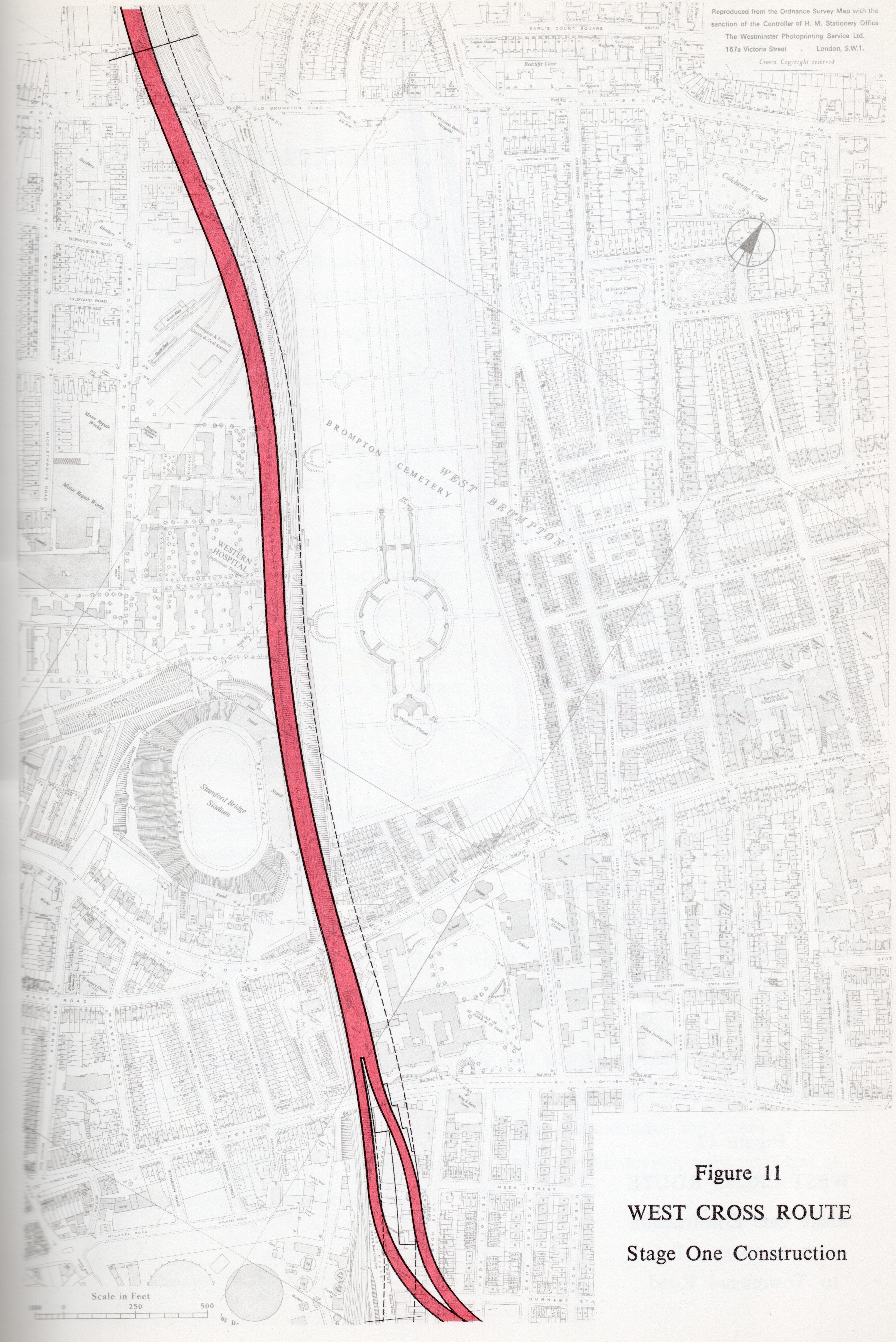
To save West London from traffic paralysis, planners created the West Cross Route. It formed the western flank of the innermost motorway circuit, “Ringway 1”, and like most of their plans it tried to minimise disruption by following an existing transport corridor - the West London Line railway, which it would shadow from Willesden to the Thames.
Half way along this route is Brompton Cemetery, where the background sound of passing trains would be replaced by the inescapable white noise of speeding traffic.
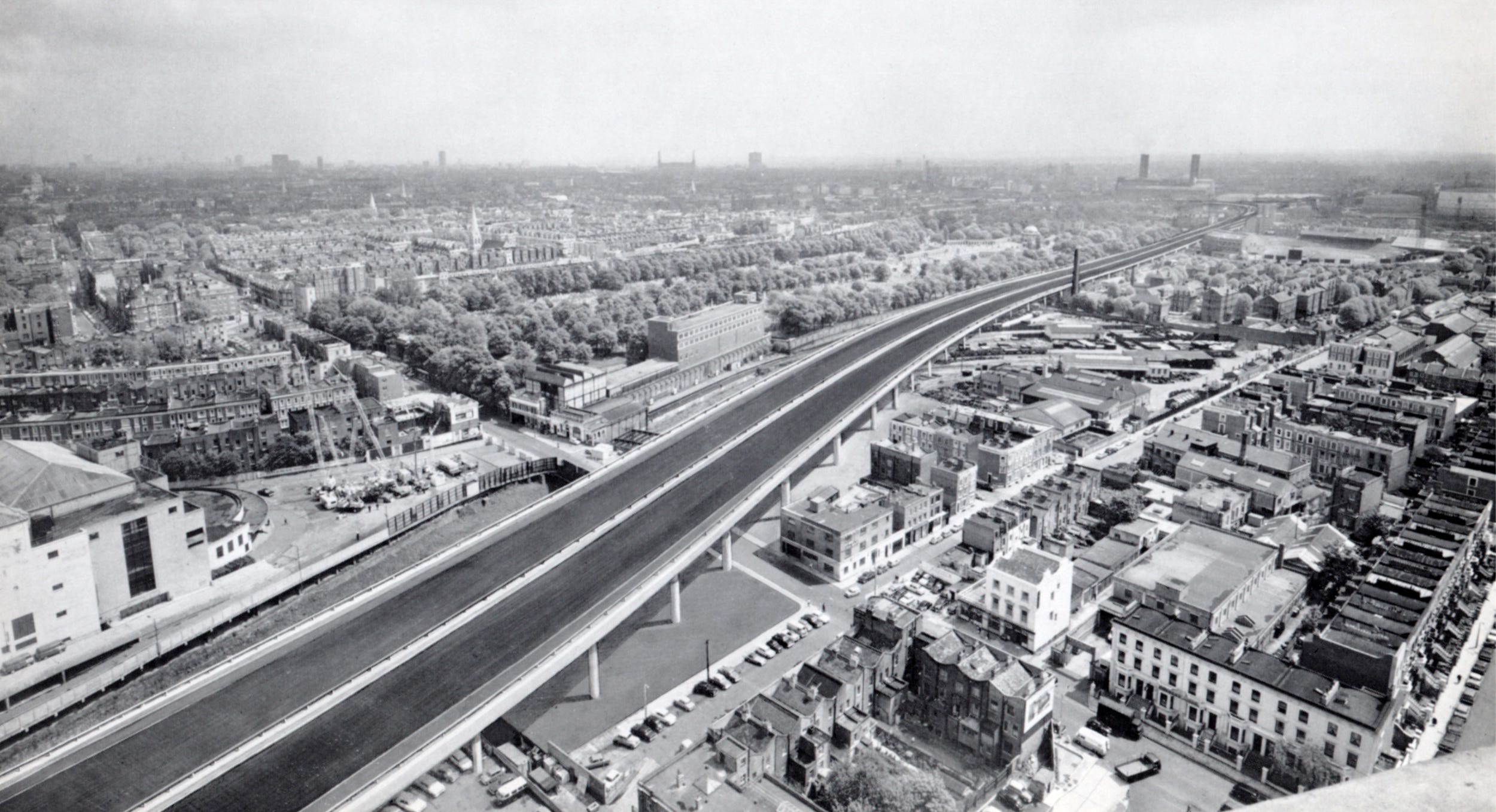
One section of this motorway was built, opened in 1970 as a short spur from the Westway. It’s since been rebuilt considerably, but it’s still there, running north from the Holland Park Roundabout. It lies to the east of the railway line, because at that point space could be made alongside the tracks, but had the motorway been extended south a more creative plan was required: it would be suspended above them.
Passing at second floor level between the terraces of Holland Park, and around the back of the Earl’s Court Exhibition Centre, the motorway would arrive at Brompton Cemetery. Here plans reveal just how little space was available between the Western Hospital on the west side of the tracks (then a major medical facility, now the site of Brampton Park) and Brompton Cemetery to the east.
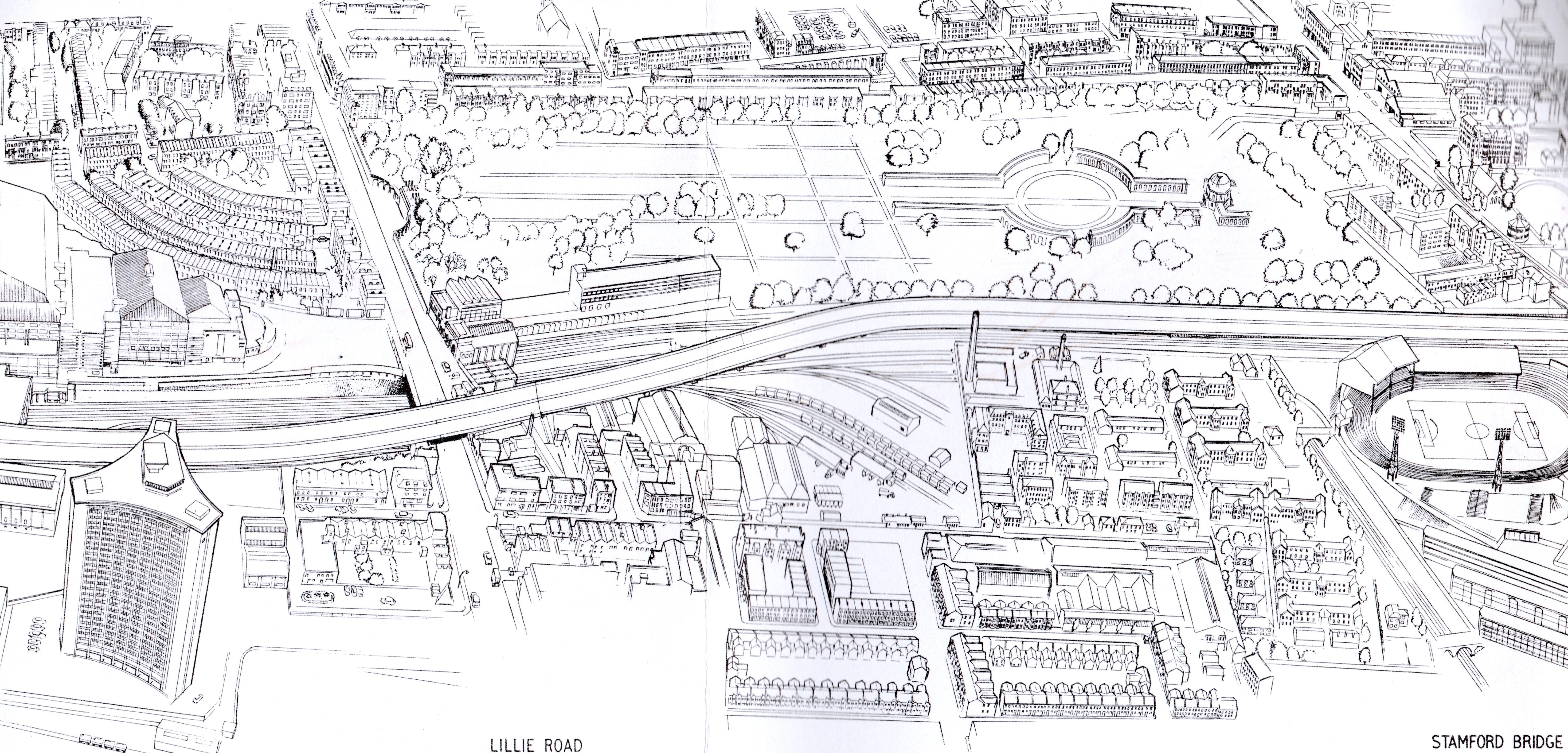
Standing above the tracks, which are themselves above the level of the Cemetery, the motorway would have used the full width of the railway land. Plans seem to show the eastern edge of the concrete viaduct running in line with the wall of the Western Catacombs, suggesting the road would have been suspended over the catacombs themselves, looming over the grounds.
To a visitor, strolling the Cemetery’s paths or admiring the central colonnade, the motorway would have stood above the tree line - if many trees survived on the western boundary - and presented the sight and sound of passing traffic as a constant backdrop. Street lights and illuminated road signs would reach above the parapets, piercing the skyline further still. It would have been an inescapable presence, replacing the Cemetery’s quiet stillness with constant noise and movement.
The West Cross Route was intended to relieve the streets of Earl’s Court, taking away the endless streams of vehicles that even now dominate Holland Road and Finborough Road. In fact, the effect of traffic on the streets in this area meant that the West Cross Route was considered one of the most urgently required new motorways - and the GLC intended to build it as quickly as possible.
At first that simply meant prioritising it ahead of other projects, but in 1970 its designers came up with a way to speed it up further: they would build half of it, so it only cost half as much, making it easier to finance and quicker to build. The other half would come later when traffic levels rose and more money was available.
Plans were drawn up for half a viaduct, wide enough for four lanes and two hard shoulders, temporarily divided for two-way traffic. But half a motorway delivers no less noise and disruption compared to a whole one, and twice as much construction work.
The GLC’s motorways would have cast the same (sometimes literal) shadow upon countless other places, of course: homes, schools and parks would have found themselves beside an unwelcome new neighbour, as the residents of North Kensington did when the Westway arrived in 1970. Indeed, Brompton wasn’t even the only cemetery on the West Cross Route: to the north, Kensal Green, another member of the “Magnificent Seven”, would have ceded a strip of land on its western edge so the enormous viaduct could march north to Willesden.
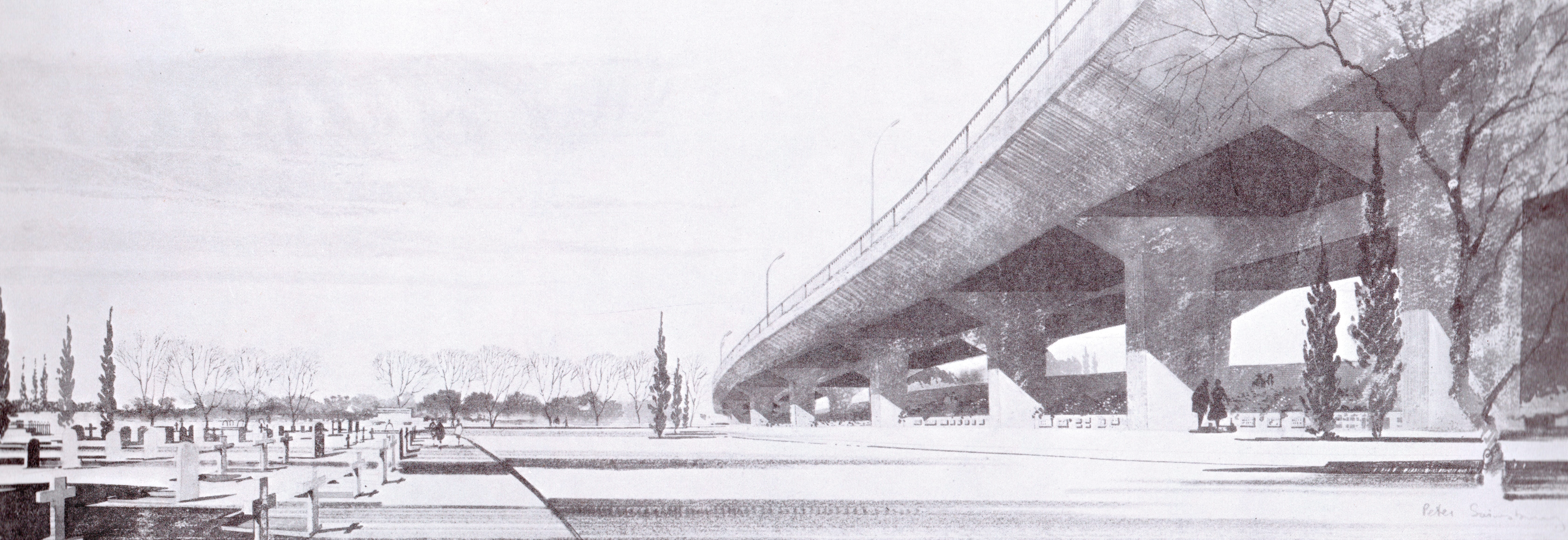
Work on the first half of the motorway was due to start in 1972 and it would open in 1975. But the bulldozers were delayed by a years-long public inquiry into the GLC’s masterplan for London, and this allowed the shifting public mood to make itself felt: there were protests, pressure from MPs and Borough Councils, and a growing realisation that urban motorways were not the only way to tame the traffic problem. In April 1973 the GLC’s new Labour administration, elected on a promise to scrap the motorways, cancelled the West Cross Route.
Brompton’s peace was not yet assured. When the GLC was abolished in 1986, the Government inherited London’s major roads, and tried to signal that it was a better custodian of the city by addressing London’s traffic. Vast projects began to upgrade the North Circular, build the M11 Link Road through Leytonstone and add flyovers and underpasses to Western Avenue.
Plans were also drawn up for something called the “WEIR” - the Western Environmental Improvement Route - that aimed, again, to relieve the Earl’s Court one-way system. It was the West Cross Route in smaller form, and plans showed a dual carriageway at ground level squeezed in between the railway tracks and the Cemetery’s western boundary.
The WEIR was not popular, and eventually was dropped - along with a host of other urban road projects - in 1990. It was the last such proposal to trouble this part of West London.
The West Cross Route was conceived in an age that had little time for conservation, when the Cemetery was closed to new burials and had no particular protection from development. Its value to Londoners, and to wildlife, bought it no special treatment, nor did its architectural treasures: the motorways would demolish plenty of those. It was luck that the motorway threatening its peace was planned above the railway, not alongside it as most would have been, and luck again that the motorway was cancelled before work could begin. Of all London’s unbuilt roads, the West Cross Route was probably the closest shave, pursued with great urgency and called off at the very last moment.
London today survives despite the volumes of traffic predicted by 1960s planners, and without needing the motorways they prescribed as the cure. In some places that compromise still grates: Holland Park Road and the Earl’s Court one way system continue to be plagued by traffic, without prospect of relief. But in others - the tranquil pathways of a Cemetery, perhaps; the peaceful green spaces that permit an escape from the constant bustle of the city - the compromise feels like one worth having.
Often, when we stop to appreciate a place like Brompton Cemetery, we’re thankful for what is there: the peace, the architecture, the greenery. Perhaps it is also sometimes worth being thankful for what is not there, and remembering the story of what didn’t happen as well as what did.
Picture credits
Artist’s impression of aerial view is from West Cross Route south of Holland Park Avenue: Consulting Engineers' Report, London County Council, April 1964, extracted from MT 106/188.
Photomontage of the West Cross Route at Brompton Cemetery is from West Cross Route Interim Engineering Report, Husband & Co., 1966.
Artist’s impression of Kensal Green Cemetery is from New Roads in West and North Central London, GLC, 1965.
Regular readers will already know that the full story of London’s unbuilt Ringways network is on the website, along with citations of the source material.
We Londoners are lucky to have escaped New York’s fate: if you have time, read Robert Caro’s excellent biography of Robert Moses (‘The Power Broker’) who bulldozed huge sections of the city and Long Island to create ‘Parkways’ and Expressways which instantly clogged up with traffic. According to the book, town planners from far and wide came to admire his work but thankfully other cities did not arrange access to the enormous funds needed to cause such destruction.
The GLC became Labour controlled in May 1973, not February.